


Action movies, adventure documentaries, and sensationalised news reports might lead some people to think otherwise, but archaeology is mostly hard, painstaking work, with very slow progress. In Central America, where most of the landmass is covered by dense rainforest, it’s even more so.
American archaeologists Arlen and Diane Chase have spent thirty-four years studying the same site, the ruins of the Mayan city of Caracol in Belize. When the Chases started, Caracol was thought to be small and insignificant among the forty or so Mayan cities in Central America. Over time, the Chases’ work helped change that perception, somewhat. But the couple felt the city’s size and importance were still being underestimated. They just couldn’t prove it.
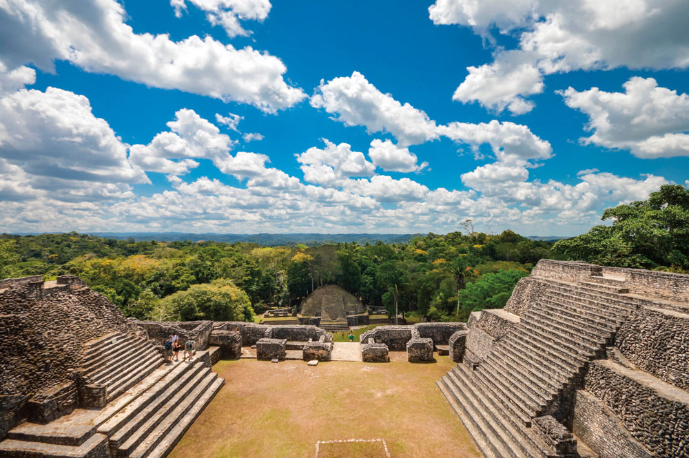
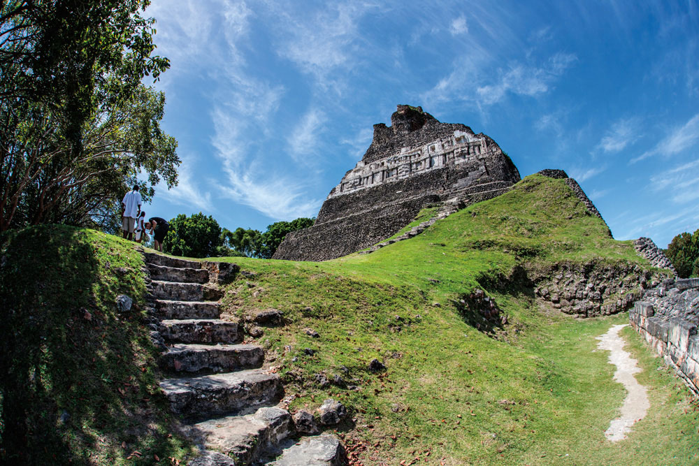
By 2009, after almost a quarter century, they’d mapped and excavated only a small section of what they believed had been a sprawling city of around 115,000 residents. Much of this work was around the city’s epicentre, which is dominated by the stone palace Caana, one of the largest man-made structures in Belize.
The Chases, frustrated by the slow pace, were looking for alternatives to the transit, a mapping tool that’s mounted on a tripod. Surveying from above was the obvious solution, but aerial photography, which has been used by archaeologists since the early twentieth century, or more recently popular satellite imagery, would both be obstructed by the thick forest cover overlaying Mayan territory. The jungle also hampers traditional archaeological efforts, as researchers and their assistants must hack through foliage with machetes before they can excavate.
Then one of the Chases’ colleagues at the University of Central Florida, biologist John F. Weishampel, recommended remote sensing technology he had been using to study forests in Costa Rica. LiDAR (which stands for light detection and ranging) sends billions of pulses of light down to the earth from the sky. The pulses hit different surfaces, then bounce back to sensors attached to an aircraft. Used along with GPS, it allows experts to make detailed three-dimensional maps. With LiDAR, scientists can digitally remove forest cover to see objects on the ground underneath. The technology has been around for decades, used primarily to map clouds and other particles in the atmosphere. It also aids navigation in self-driving vehicles.
Archaeologists had attempted to use it earlier, but didn’t get satisfactory results. But by the turn of the century, the technology had improved considerably.
After discussions with Weishampel, the Chases decided to try LiDAR themselves. They started applying for grants. “Everybody said we were crazy, that we weren’t going to get it,” Arlen Chase recalls. But in 2009, after “the sixth or seventh” try, the team received US$400,000 from NASA, which wants to promote different uses for LiDAR.
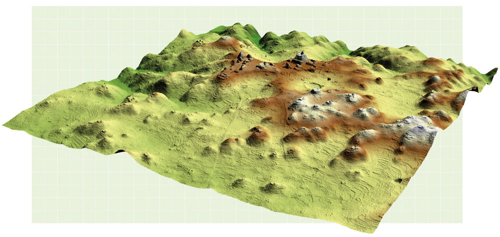
Over four days, a LiDAR-equipped twin-engine plane covered two hundred square kilometres around the Caracol area, and picked up ruins previously undiscovered by modern researchers. The Chases were able to see settlement structures far beyond the epicentre: reservoirs, buildings, roadways, and — perhaps most important — agricultural terraces, which show that Caracol residents used sophisticated water-conserving techniques to feed a relatively large population. The LiDAR images even revealed structures the team had missed in areas they’d previously mapped.
“It worked beyond our wildest dreams,” says Chase. “It was the first time there was large-scale LiDAR done in the Caribbean and in the Maya area.”
Since that first try, LiDAR use has been spreading across Central America, the Caribbean, and indeed the world.
In 2012, filmmaker and explorer Steve Elkins, who’d been searching northeastern Honduras for a “lost city,” convinced the organisation that conducted the Caracol surveys, the National Centre for Airborne Laser Mapping, to help. To the surprise of many, the survey turned up hitherto undiscovered ruins of an ancient city.
In Guatemala, the largest ever LiDAR archaeological project took place in 2016, and is due to continue later this year. Over twelve days, a small plane surveyed more than 2,100 square kilometres of the Maya Biosphere Reserve in northern Guatemala. Researchers discovered sixty thousand ancient structures, which suggested millions more people lived in the area than previously thought.
Outside of archaeology, LiDAR is being used to put together the first high-resolution map of Caribbean coral reefs, in a bid to document and reverse their degradation. The technology will also be used over the next three years to map ten thousand square kilometres of coastal land in the region, to monitor the effects of climate change, in a project spearheaded by the Caricom Climate Change Centre and financed by the Caribbean Development Bank, USAID, and the Italian government. “Everybody wants it. It’s absolutely amazing,” says Arlen Chase.
One of the researchers with the Guatemala project, Steven Houston, told the BBC, “This is one of the greatest advances in over 150 years of Maya archaeology. I know it sounds hyperbolic, but when I saw the [LiDAR] imagery, it did bring tears to my eyes.” To understand the feeling, you have to appreciate what the findings could mean from an academic and sociological perspective. Researchers and descendants can now see that the Mayan civilisation — which existed between 1000 BC and 900 AD, leaving behind huge, intricately designed stone pyramids and other monuments that have become major tourist attractions in Central America and parts of Mexico — may rival the great ancient civilisations of Greece and China.
As an article written by the Chases and Weishampel and published in 2010 in Archaeology magazine explains: “The airborne LiDAR data will help us finally dispel preconceived notions about ancient tropical civilisations — that they were limited in size and sophistication — by letting us peer through the trees.”
In 2013, the Chases embarked on an even more ambitious LiDAR project, coordinating a fourteen-day survey of more than a thousand square kilometres in west-central Belize — incorporating multiple Mayan sites and allowing researchers to compare them and see the physical relationships among them.
LiDAR saves time, and despite the high up-front costs, its proponents believe it ultimately saves money that would have been spent on years of archaeological expeditions. It also allows governments to do more to plan modern development around the ruins and protect them from looters.
But it isn’t a substitute for old-fashioned archaeology. An important part of using LiDAR is what researchers call “ground-truthing.” “You have to be careful with your analysis and your interpretation of what you’re seeing,” says Melissa Badillo, a researcher with the Belize Institute of Archaeology. “And the only way you can be certain is by actually walking out there and checking it to make sure.”
Badillo will be the first Belizean woman with an archaeology PhD when she graduates in a few years from the University of Nevada, where her mentors, the Chases, are now based. The director of the Institute of Archaeology — which earns money from tourism to maintain the ruins and educate people about them — is also a former Chase student with a PhD. It’s hoped that the LiDAR revelations will attract more tourists and also draw young Belizeans into archaeology.
“It is a growing field in Belize,” says Badillo. “There are several other younger students in the streamline right now pursuing a degree in archaeology.” And as the LiDAR data suggest, there are decades’ worth of exciting work for them to do — as they uncover how a great early civilisation may have been even greater.