


About an hour into the hike to Paria Bay, I lost my sole. More precisely, the sole of my left sneaker. Perhaps it was not entirely unexpected. My favourite and most comfortable sneakers were at least eight years old, visibly tattered, and I’d wondered if they were up to one last big hike. The answer came on an uphill stretch of the trail which recent rain had churned up into a slick of mud.
Some prompt bush engineering was called for. Luckily, my companions were an architect and a designer. With a length of wiry vine, a shoelace rejigging, and a few careful knots, my left sneaker was soon sufficiently repaired to get me through the rest of the day, and I could once more turn my focus from the state of my footwear to the spirit-raising scenery of Trinidad’s north coast trail.
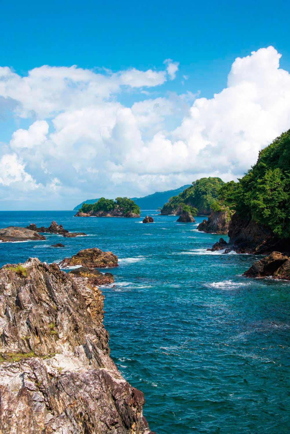
In most Caribbean islands, you can follow almost the entire coastline by paved road. But thanks to overlapping quirks of geography and history, the north coast of Trinidad — a fifty-mile expanse between Scotland Bay in the west and Point Galera in the east — is only partly accessible by road. The island’s Northern Range rises abruptly from the sea, creating a dramatic landscape of forested slopes, sheer rock cliffs, and sandy bays, but the mountains also cut off the north coast from the populous plains to the south. In the nineteenth century, as Trinidad’s agricultural economy shifted from lowland sugar to hillside cocoa and coffee, numerous small estates were established here, connected to the capital, Port of Spain, by boat. But the tiny villages and homesteads dotted along this wild, beautiful coast remained relatively isolated for decades.
Then came the Second World War. The British government leased Trinidad’s Chaguaramas Peninsula to the United States to establish a sprawling military base, and residents of Port of Spain were suddenly deprived of their most accessible beaches. In recompense — the story goes — the US Army carved a winding road up through the Northern Range to Maracas Bay, which soon became, and remains, Trinidad’s most popular beach, as famous for its shark-and-bake vendors as for its broad horseshoe of sand.
Today the North Coast Road runs past Maracas and Las Cuevas to the village of Blanchisseuse, halfway along the coast. At the island’s northeastern tip, the villages of Toco, Grande Riviere, and Matelot are similarly connected to the eastern towns of Sangre Grande and Arima. But the central eleven-mile stretch of coast remains inaccessible by car — a largely unspoiled reach best known to fishermen, hikers, and campers.
Coming from the west, the hike to Paria Bay starts more or less at the Blanchisseuse Spring Bridge — a historic suspension bridge over the Marianne River. A ninety-minute drive from Port of Spain, the bridge marks the end of the paved thoroughfare and the start of a dirt road which tends in the rainy season to a condition of muddy adventure. The first couple of miles past this point, beach houses perch along the rugged shoreline, eventually giving way to modest farms.
At small Laspor Bay with its rocky stacks, the hike really begins. The trail narrows to single file, and enters what feels like true wilderness.
Various hiking guides and websites describe the Paria trail as anything from moderately challenging to difficult. The challenge depends partly on your fitness level and, indeed, partly on the weather — several months into the rainy season, parts of the trail can be a muddy slog. But the topography offers a welcome alternation of uphill and downhill slopes, and long level stretches no more strenuous than a stroll. Experienced Paria hikers know that on the outbound journey, the second of the big “hills” after Laspor is the toughest.
Mostly hugging the coastline, with inspiring views of glistening water and crashing waves far below, the route occasionally veers inland. It’s all but impossible to get lost — this trail has been well tended for generations. On official maps of Trinidad, it’s even labelled as the Paria Main Road — a name that dates back a century and a half, to when the trail was first cut to allow access on foot or by donkey to the old cocoa estates.
The sights and scents of the forest change gradually over the months, as different trees move through their blossoming and fruiting seasons — today you catch a whiff of ripe hog plums, another time it might be the musky perfume of a flowering cannonball tree. You can see or hear dozens of bird species flitting through the forest canopy. And it’s easy to spot one of the trail’s most striking wildlife species, the emperor butterfly, its wings flashing a brilliant iridescent blue as it lazily flutters by. Meanwhile the sea breeze never pauses, rustling among the treetops.
An hour past Laspor Bay, keep an eye out for Turtle Rock, a gnarled outcropping jutting into the sea. A narrow branch off the main trail descends through wind-stunted trees to the giant crag, offering views for miles up and down the coast. It’s the place to pause for a snack, catch your breath, take a selfie or two, before the last stretch of trail.
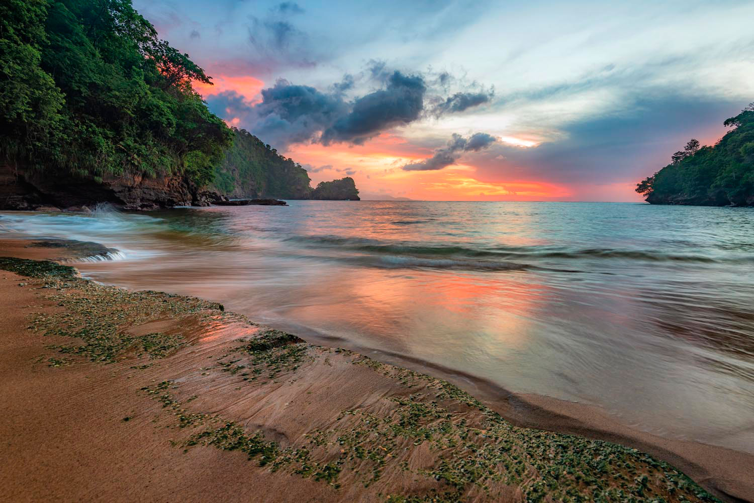
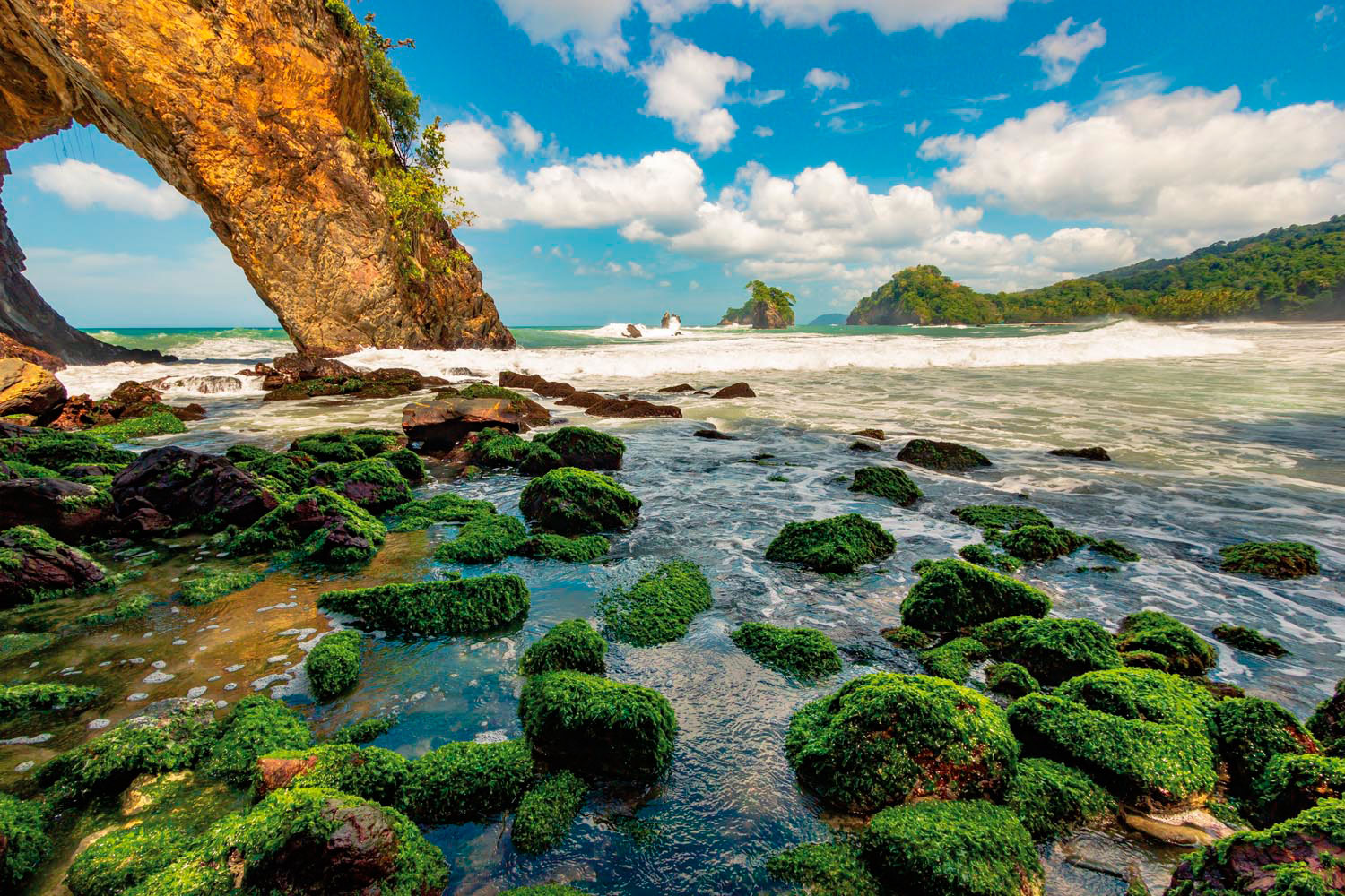
Paria Bay announces itself with the so-called Cathedral Arch, an example of nature’s own architecture and an almost obligatory backdrop for photos. It marks the westen end of the bay, a half-mile sweep of sand and pounding waves. Fill your lungs with sea air, and revel in the view. If you’re tempted to a swim, trek down to the farther end of the bay, where a patch near the mouth of the river is sheltered from the swells and tides.
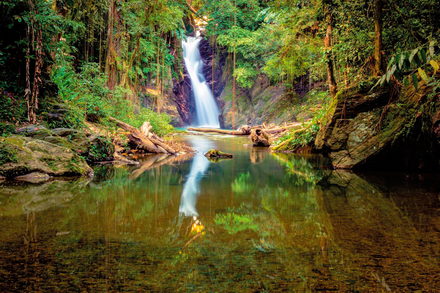
But the day’s adventure isn’t over. You’ll have to get back on the trail to experience Paria’s true gem. Halfway along the beach, a sandy trail heads inland before meeting the bank of the Paria River. Clumps of bamboo offer shade, and soon you’ll hear the muffled rush of the Paria waterfall. It takes a bit of a rocky scramble — or a wade and swim — to get to the natural pool where the waterfall cascades thirty feet into cold, emerald-green water. Most days, you’ll have this gorgeous spot to yourself. Flowering trees tower high above the gorge and schools of small fish dart around your knees as you ease your way into the pool. Float away and let the delicious cool soothe your aching muscles. Let your senses free.
Preparing for the Paria trail
Depending on your level of fitness, the hike from Blanchisseuse to Paria Bay should take approximately two to three hours each way. Leave as early as you can, to get started before the hottest part of the day. The trail includes some fairly steep stretches, but nothing too strenuous for a fit hiker. Wear sturdy sneakers or hiking shoes — and consider boots in the rainy season, when conditions can get muddy. A trekking pole or walking stick may be helpful on the includes and declines. You’ll almost certainly want a sea or river bath at Paria, so wear or bring a swimsuit and lightweight towel. Make sure to bring adequate water — you’ll probably want two litres per person for the entire day. The trail crosses several small streams that are usually safe to drink from, once the water is running freely. Time your departure from Paria to allow enough time to get back to your car.
If a full day on the trail sounds too strenuous, you can also get to Paria by boat from Blanchisseuse, though it can be a choppy ride.
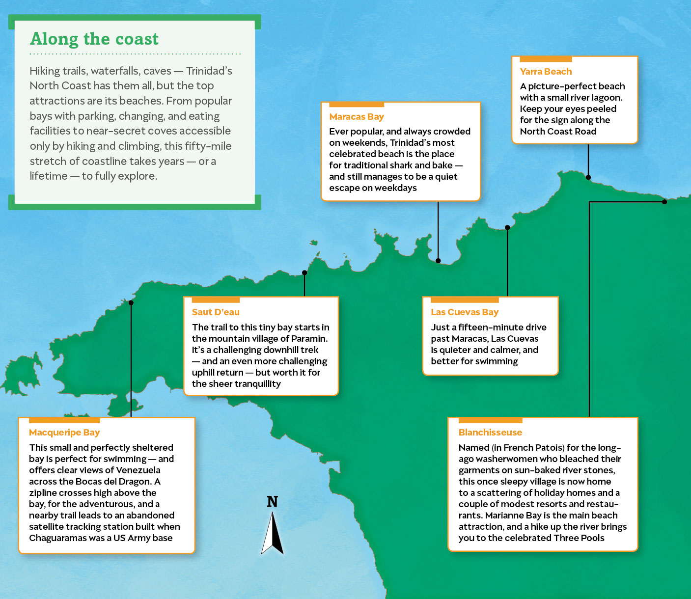
Along the coast
Hiking trails, waterfalls, caves — Trinidad’s North Coast has them all, but the top attractions are its beaches. From popular bays with parking, changing, and eating facilities to near-secret coves accessible only by hiking and climbing, this fifty-mile stretch of coastline takes years — or a lifetime — to fully explore.
Macqueripe Bay
This small and perfectly sheltered bay is perfect for swimming — and offers clear views of Venezuela across the Bocas del Dragon. A zipline crosses high above the bay, for the adventurous, and a nearby trail leads to an abandoned satellite tracking station built when Chaguaramas was a US Army base.
Saut D’eau
The trail to this tiny bay starts in the mountain village of Paramin. It’s a challenging downhill trek — and an even more challenging uphill return — but worth it for the sheer tranquillity.
Maracas Bay
Ever popular, and always crowded on weekends, Trinidad’s most celebrated beach is the place for traditional shark and bake — and still manages to be a quiet escape on weekdays.
Las Cuevas Bay
Just a fifteen-minute drive past Maracas, Las Cuevas is quieter and calmer, and better for swimming.
Yarra Beach
A picture-perfect beach with a small river lagoon. Keep your eyes peeled for the sign along the North Coast Road.
Blanchisseuse
Named (in French Patois) for the long-ago washerwomen who bleached their garments on sun-baked river stones, this once sleepy village is now home to a scattering of holiday homes and a couple of modest resorts and restaurants. Marianne Bay is the main beach attraction, and a hike up the river brings you to the celebrated Three Pools.
Paria Bay
The broad beach lined with coconut trees and the perfect waterfall are rivals for the main attraction at Paria.
Gran Tacarib
A couple hours’ hike past Paria, Grand Tac feels a world away from
Trinidad’s bustle. Great for an overnight camping trip, or accessible via a (usually rough) boat ride.
Madamas Bay
Some call it the most beautiful beach on the north coast, with its fine sand, clear lagoon, and hills towering behind. It’s also one of the most remote.
Matelot
In Trinidad, the name of this village is almost proverbial for somewhere far away. It’s the end of the paved road from Toco — “behind God’s back,” residents will tell you with some pride.
Grande Riviere
In recent decades, the beach at Grande Riviere has become celebrated as one of the best places in the world to see endangered leatherback turtles as they come ashore to lay their eggs.
Toco
This quiet, close-knit village strung out along the coast is the closest part of Trinidad to the sister isle, Tobago.
Point Galera
The Northern Range tumbles into the waves where the Caribbean Sea meets the Atlantic Ocean — overlooked by a white-painted Victorian lighthouse.


